Results 1 to 10 of 10

Thread: 17th and 18th Century coastal fortifications.

  1. #1
    Admiral of the Fleet.
    Baron
    England

    Join Date
    Nov 2011
    Location
    Notts
    Log Entries
    22,305
    Blog Entries
    22
    Name
    Rob

    Default 17th and 18th Century coastal fortifications.


    English Fortifications.

    With the idea of looking at some scenery for enemy attacks on the U.K. I came across these photos in my research, and wondered if they were of any use to other members? They cover all sorts of defences from the minimalist Yarmouth, to the gargantuan, such as Dover.

    Name:  1280px-Yarmouth_-_Harbour_with_Castle.jpg
Views: 5416
Size:  175.0 KB
    Yarmouth Castle I.O.W.

    Name:  dover-castle.jpg
Views: 5100
Size:  101.6 KB
    Dover Castle.

    Name:  Pendennis_Castle.jpg
Views: 4964
Size:  142.8 KB
    Pendennis Castle.


    Name:  St Mary's scillies.jpg
Views: 3853
Size:  62.3 KB
    St Mary's Scilly isles.

    Name:  st-mawes.jpg
Views: 4927
Size:  133.2 KB
    St Mawes. Cornwall.


    Name:  southsea castle.jpg
Views: 7126
Size:  108.2 KB
    And finally Southsea Castle at the entrance to Portsmouth.
    This last actually has two models already made for it pre 1850s and post 1850s by Brigade models.

    Name:  Brigade model southsea castle.jpg
Views: 3727
Size:  30.8 KB

    Rob.
    Last edited by Bligh; 12-14-2016 at 13:55.

  2. #2

  3. #3
    Admiral of the Fleet.
    Baron
    England

    Join Date
    Nov 2011
    Location
    Notts
    Log Entries
    22,305
    Blog Entries
    22
    Name
    Rob

    Default

    North American Fortifications.


    Name:  BlockhouseE.jpg
Views: 4102
Size:  39.4 KB
    The First System forts were built during and after the Revolutionary War. Made of wood, dirt and stone, they were generally open parapets with no overhead cover or defensive layers. They were built in close to harbors to protect them.

    Name:  Jamestown.jpg
Views: 3759
Size:  42.0 KB


    Jamestown 1608


    Of the 21 sites selected for forts, most were never started and few were completed. One of the big problems was a lack of trained American engineers. The War Department, under Henry Knox (the namesake of Fort Knox) was forced to bring in European engineers to design and build American forts - not a good idea if you thought war with the Europeans was coming. In the end, war did come in 1812 but by then, the first system forts had already deteriorated past usefulness.
    Name:  Fort Astoria.jpg
Views: 11063
Size:  216.8 KBFort Astoria 1813
    Second system forts.In 1794, facing the possibility of yet another war with the European continent, Washington ordered the construction of a series of fortifications to protect American ports and waterways. It set in motion a strategy for the defense of the United States mainland using powerful fixed fortifications at key points.


    Name:  FortMcHenryAerial.jpg
Views: 4426
Size:  48.7 KB

    Fort McHenry is a Second System fort located on Locust Point in Baltimore Harbor. It is one of the few seacoast defense forts of any system to actually accomplish what it was designed to do - engage and defeat an enemy seaborne threat. In this case, it was the British invasion force that had just burned Washington, D.C. during the War of 1812. Completed in 1802, it stood ready for 12 years until 1814 and became immortalized in one day of furious action. Although it looks much like a Third System fort, its guns are all parapet mounted en barbette. If Fort McHenry had fought a similar action against the Union Navy during the Civil War, it wouldn't have lasted the same 25 hours and it wouldn't have defeated the fleet. By that time, the ships had the upper hand and brick forts were obsolete.


    Name:  Fort-Jackson.jpg
Views: 3807
Size:  43.0 KB

    Fort Jackson.


    Name:  300px-FortAdamsModern_RI.jpg
Views: 4071
Size:  20.6 KB


    Name:  795px-Ft_Adams_-_005.jpg
Views: 3928
Size:  47.1 KB

    Fort Adams.

    As naval weaponry strength increased in the early nineteenth century, forts close to major ports or industrial centers were not viewed as effective defenses. The federal government ordered the construction of a new fort on Pea Patch Island, closer to Delaware Bay, which could provide adequate protection to Philadelphia and other manufacturing cities such as Chester, Pennsylvania, and Wilmington, Delaware. Construction started on the initial Fort Delaware after the War of 1812, but it was never completed because of a fire in 1831. Construction of a second Fort Delaware, with a different design and constructed primarily from brick and stone, started in 1833.

    Name:  Fort-Delaware-air-575x409.jpg
Views: 3663
Size:  59.7 KB


    Rob.
    Last edited by Bligh; 12-15-2016 at 08:18.

  4. #4
    Admiral of the Fleet.
    Baron
    England

    Join Date
    Nov 2011
    Location
    Notts
    Log Entries
    22,305
    Blog Entries
    22
    Name
    Rob

    Default

    Central American forts.


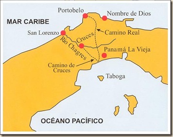
    Fuerte San Lorenzo is a ruined Spanish fort overlooking the mouth of the Chagres river about seven miles West of the Atlantic entrance to the Panama Canal.


    In the early 16th century the Spanish were stealing the Inca gold from Peru and operating their own mines there using enslaved native Indians. This plunder was shipped to Panama City on the Pacific Ocean then transported across the Isthmus of Panama to the Caribbean for transshipment to Havana then on to Seville, Spain. The easiest route across the Isthmus was called the Camino de Cruces which followed the Chagres River for its last twenty miles. Just as this Camino was the easiest route to move gold from Panama City, it was also the easiest route for pirates to follow to attack the city. Therefore: defending the mouth of the Chagres at San Lorenzo was important to Spain.


    Name:  AirealView3.jpg
Views: 3676
Size:  53.9 KB

    Fuerte San Lorenzo


    Fuerte San Diego Acapulco Mexico

    Name:  Acapulco 3 Fuerto San Diego 0[9].jpg
Views: 3691
Size:  215.1 KB

    Fuerte San Diego is a classic bastioned star fort based upon a regular pentagon. The great military engineer Vauban proposed low forts with thick walls to withstand cannon fire that had obsoleted medieval forts with their high thin walls. He also perfected the star fort layout such that each face of the fort could be swept by some of its own cannons. Thus, there are no blind spots out of the reach of its guns. The regularity of the fort suggests that the designers regarded a land based attack as an equal threat to sea side attack. In fact, the only time the fort fell it fell to a land attach during the revolution in the early 1800’s.

    Name:  Acapulco 3 Fuerto San Diego 3_thumb[2].jpg
Views: 3545
Size:  26.6 KB


    The Castillo San Felipe de Barajas is a fortress in the city of Cartagena, Colombia. The castle is located on the Hill of San Lázaro in a strategic location, dominating approaches to the city by land or sea. It was built by the Spanish during the colonial era. Construction began in the year 1536, and it was originally known as the Castillo de San Lázaro, It was expanded in 1657.

    Name:  1280px-62_-_Carthagène_-_Décembre_2008.jpg
Views: 3426
Size:  174.4 KB

    The fortress was begun in 1536. It was significantly expanded in 1657. It was built in a triangular shape on top of the hill, with eight batteries and a garrison of 20 soldiers and 4 gunners. Its name was given in honour of Philip IV of Spain.[1] Another expansion was made to the fortress in 1763 by Antonio de Arévalo.[2]
    In the 1697 raid on Cartagena, during the War of the Grand Alliance, the castle fell to the French privateer Baron de Pointis. The castle was repaired by José de Herrera y Sotomayor in 1739. British Admiral Edward Vernon attacked the fortress in the 1741 Battle of Cartagena de Indias, an important conflict of the War of Jenkins' Ear. Vernon's forces were repelled by the Spanish admiral Blas de Lezo.
    During the Spanish American wars of independence by mid-1815 a large Spanish expeditionary force under Pablo Morillo had arrived in New Granada. Cartagena fell in December, and by May 1816 the royalists had control of all of New Granada.


    Name:  1280px-62_-_Carthagène_-_Décembre_2008.jpg
Views: 3394
Size:  70.8 KB


    Rob.
    Last edited by Bligh; 12-18-2016 at 07:17.

  5. #5
    Admiral of the Fleet.
    Baron
    England

    Join Date
    Nov 2011
    Location
    Notts
    Log Entries
    22,305
    Blog Entries
    22
    Name
    Rob

    Default

    Caribbean forts.

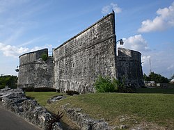
    Fort Charlotte is a British-colonial era fort built on a hill over-looking the harbor of Nassau, The Bahamas. The fort sits a short walk west of downtown Nassau and the cruise ship terminal. The fort was constructed in the late 18th century by British colonial governor Lord Dunmore after the end of the American Revolutionary war. The fort has never been used in battle.

    Name:  Fort_Charlotte,_Nassau,_The_Bahamas.jpg
Views: 3471
Size:  103.8 KB


    Fort Fincastle

    The fort was built in 1793 by Lord Dunmore. Built around 1793 on Society Hill, the fort overlooks the city of Nassau and the Queen’s Staircase, and is often accessed that way by visitors on foot. This fort shaped like a paddle-steamer, Lord Dunmore called Fort Fincastle, after his second title, Viscount Fincastle. The fort overlooked Nassau and Paradise Island and the eastern approaches to New Providence. It mounted two 24 pounders, two 32 pounders, two 12 pounder cannons and one howitzer. It served as a lighthouse until September 1817 when it was replaced by the lighthouse on Paradise Island. It was subsequently used as a signal station.


    Fort James is a fort at the entrance to the harbour of St. John's, Antigua and Barbuda. The fort was built to guard St. John's harbour and is one of the many forts built by the British in the 18th century. Fear of a French invasion prompted the construction. It is located on a headland overlooking the town northwesterly. A powder magazine, several cannons and the foundation of the fort's wall remain. The main attraction today is the excellent view of the surrounding harbor.
    The fort is named after King James II of England. Work on the fort started in 1706, and most of the buildings were built in 1739. In 1773, the fort was armed with 36 guns, and had a barracks which accommodated 75 men. In the 19th century, a gun fired salutes at visiting warships, as well as signals at sunrise and sunset.


    Name:  1280px-FORT_JAMES,_ST__JOHN'S,_ANTIGUA.jpg
Views: 3426
Size:  146.2 KB


    Fort St. Catherine, or Fort St. Catherine's (as it is usually referred to), is a coastal artillery fort at the North-East tip of St. George's Island, Bermuda. Successively redeveloped, the fort was used first by Bermudian Militia and then by regular Royal Artillery units from 1612 into the 20th Century. Today it houses a museum.

    Name:  1024px-Fort_St__Catherine's,_St__George's_Island,_Bermuda.jpg
Views: 3783
Size:  115.0 KB


    Brimstone Hill Fortress National Park is a UNESCO World Heritage Site, a well-preserved fortress on a hill on the island of St. Kitts in the Federation of St. Christopher (St. Kitts) and Nevis in the Eastern Caribbean. It was designed by British military engineers, and was built and maintained by African slaves. It is one of the best preserved historical fortifications in the Americas.
    The complex of fortifications were constructed on Brimstone Hill, a very steeply sloping hill situated close to the sea on the Western, Caribbean coast of St. Kitts.

    Name:  BrimstoneHill01.jpg
Views: 4032
Size:  244.8 KB


    Fortín San Juan de la Cruz (Fort Saint John of the Cross), known locally as El Cañuelo, was built on Isla de Cabras Island at the western end of the entrance to San Juan Bay, in Puerto Rico. The square coastal fort has massive sandstone walls that date back to the 1630s. Although the U.S. Navy bombarded the fort in 1898, the fort survived. Today the fort is part of the San Juan National Historic Site, which is listed as a UNESCO World Heritage Site and on the National Register of Historic Places.


    Name:  Fortín_San_Juan_de_la_Cruz_-_El_Canuelo.jpg
Views: 4300
Size:  193.7 KB


    Castillo San Cristóbal,[3] also known as Fort San Cristóbal, is a fort in San Juan, Puerto Rico. It was built by Spain to protect against land based attacks on the city of San Juan. It is part of San Juan National Historic Site.
    Castillo San Cristóbal is the largest fortification built by the Spanish in the New World. When it was finished in 1783, it covered about 27 acres of land and basically wrapped around the city of San Juan. Entry to the city was sealed by San Cristóbal's double gates. After close to one hundred years of relative peace in the area, part of the fortification (about a third) was demolished in 1897 to help ease the flow of traffic in and out of the walled city.
    This fortress was built on a hill originally known as the Cerro de la Horca or the Cerro del Quemadero, which was changed to Cerro de San Cristóbal in celebration of the Spanish victories ejecting English and Dutch interlopers from the island of this name in the Lesser Antilles, then forming part of the insular territorial glacis of Puerto Rico.
    Castillo de San Cristóbal (Fort San Cristóbal) also contains cisterns, that were used for the transport of water during the ages of the Spanish Colony. They are extremely huge (30ft tall, 60ft wide and 100ft long) and were used as bomb shelters during World War II. They could be used for a future war again with some refurbishments.


    Name:  Aerial_view_of_Castillo_de_San_Cristobal,_San_Juan,_Puerto_Rico.jpg
Views: 3562
Size:  365.7 KB


    Fortín de San Gerónimo del Boquerón is a small fort located in the mouth of the Condado Lagoon, across from the historic sector of Miramar in San Juan, Puerto Rico.
    It was built during the 17th century to replace a smaller battery (called El Boquerón) that stood at the easternmost end of the San Juan islet. The original Boquerón battery was used by the Spanish to defend the city of San Juan from attacks by Sir Francis Drake in 1595 and George Clifford, the third Earl of Cumberland in 1598, who managed to destroy it during his attack. San Gerónimo became part of San Juan's first line of defense, along with the San Antonio Fort/Bridge and Escambrón Fort, being the fourth and last line of defense the formidable Castillo de San Cristóbal, which guarded the city entrance proper.


    Name:  San_Jeronimo_aerial.jpg
Views: 3696
Size:  104.2 KB


    Castillo San Felipe del Morro also known as Fuerte San Felipe del Morro or Castillo del Morro, is a 16th-century citadel located in San Juan, Puerto Rico
    Name:  FortElMorro_SanJuan_PuertoRico.jpg
Views: 3560
Size:  259.5 KB


    Rob.
    Last edited by Bligh; 12-15-2016 at 13:21.

  6. #6
    Admiral of the Fleet.
    Baron
    England

    Join Date
    Nov 2011
    Location
    Notts
    Log Entries
    22,305
    Blog Entries
    22
    Name
    Rob

    Default


    Brazilian Forts.

    https://en.wikipedia.org/wiki/List_of_fortsThe Fort of Santa Cruz de Itamaracá, popularly known as Fort Orange, located on Itamaracá Island on the north coast of the state of Pernambuco in Brazil.
    In the context of the second Dutch invasions in Brazil, it was originally a small island (now lost) in front of the tip of the Southeast Itamaracá Island, where the bar dominated the southern channel of Santa Cruz .

    Name:  1024px-Fort_Orange.jpg
Views: 3404
Size:  185.2 KB
    Forte de Santa Cruz de Itamaraca, Brazil: A view from inside.
    The 'Forte dos Reis Magos or Fortaleza dos Reis Magos (Fortress of the Three Wise Men), is a fortress located in the city of Natal in the Brazilian state of Rio Grande do Norte.
    The fortress was the first milestone of the city - founded on 25 December 1599 - on the right side of the bar of the Potengi River (today near the Newton Navarro bridge). It received its name based on the date of commencement of its construction, 6 January 1598, at Epiphany Catholic calendar.
     / -5.75639; -35.19472

    Name:  Forte-reis-magos.jpg
Views: 3477
Size:  194.2 KB


    The Fortaleza de São João da Barra do Rio de Janeiro (
    Portuguese for: Fortress of Saint John of the Harbor of Rio de Janeiro), popularly known as the Fortaleza de São João or Forte (de) São João (Fort (of) Saint John), is a 16th-century star fort in the present-day Urca neighborhood of Rio de Janeiro, erected by Estácio de Sá to protect Guanabara Bay from French invasion.

    Name:  1024px-SaoJoaoFort.jpg
Views: 3416
Size:  249.6 KB


    São Marcelo Fort or Forte de Nossa Senhora do Pópulo e São Marcelo is located in
    Salvador in Bahia, Brazil. It is located in small bit of land off the coast of Baía de Todos os Santos.
    The Fort was designed and construction started in 1608 under Francisco Frias Mosque and was completed in 1623. It was built to protect the important port city Salvador from threats.

    Name:  Forte_São_Marcelo.jpg
Views: 3344
Size:  7.5 KB

    Name:  SMarceloFort-Salvador-CCBY.jpg
Views: 3474
Size:  82.5 KB

    Name:  Vista_aérea_do_Forte_de_São_Marcelo.jpg
Views: 3472
Size:  158.9 KB


    Rob.

  7. #7
    Admiral of the Fleet.
    Baron
    England

    Join Date
    Nov 2011
    Location
    Notts
    Log Entries
    22,305
    Blog Entries
    22
    Name
    Rob

    Default


    Channel Island Forts.


    Name:  My_home_for_the_week_2555778881439050871_Photo.jpg
Views: 3998
Size:  150.8 KB

    Fort Clonque is a 19th-century coastal fortress in Alderney, in the Bailiwick of Guernsey in the Channel Islands. It was constructed at a time when French naval power was becoming an increasing concern to the British. It is built on a rocky outcrop of land joined to the island by a causeway that can be submerged at high tide. It was manned by fifty men and fortified with up to ten guns, mostly 68-pounders, however none was ever fired in anger.

    Name:  Alderney_-_Fort_Clonque_02.jpg
Views: 3376
Size:  113.7 KB
    Fort Clonque at low tide.


    Name:  1024px-Fort_Hommet,_with_Victorian_and_German_accretions_2.jpg
Views: 3814
Size:  185.4 KB

    Fort Hommet (or Fort Houmet) is a fortification on Vazon Bay headland (or
    houmet in Guernésiais) in Castel, Guernsey. It is built on the site of fortifications that date back to 1680, and consists of a Martello tower from 1804, later additions during the Victorian Era, and bunkers and casemates that the Germans constructed during World War II.

    Name:  Guernsey_July_2010_62,_Fort_Hommet.jpg
Views: 4204
Size:  315.3 KB


    Fort George is situated in
    Saint Peter Port, Guernsey, and was built to become the main island military headquarters and to protect barracks to house the island garrison for the British Army, in place of Castle Cornet.
    Planned during the
    Anglo-French War (1778–83), construction started in 1780, and was completed in 1812. It was built to accommodate the increase in the number of troops stationed in the island to deter the anticipated French invasion, such as the attempted Jersey one in 1779 and the one that resulted in French troops landing in Jersey in January 1781, which resulted in the Battle of Jersey in the centre of Saint Helier.


    Name:  Clarence_Battery_at_Fort_George,_Guernsey_(2014).jpg
Views: 3692
Size:  161.0 KB
    Clarence battery Fort George

    Fort Grey, colloquially known as the "cup and saucer", is a
    Martello tower located on a tidal rock in Rocquaine Bay in Saint Peter, Guernsey.

    Name:  1280px-Fort_Grey.jpg
Views: 3554
Size:  120.3 KB

    The existing fort was built on the remnants of the old Chateau. Its white tower was originally built as a defence by the
    British in 1804 during the Napoleonic Wars, the builder was a local man, Thomas Henry from Clos du Valle The fort was named after Charles Grey, 1st Earl Grey, who was Governor of Guernsey from 1797 to 1807.[5][6] It was made one of three locations in the island where a warning gun would be fired in case of invasion.


    Fort Regent is a 19th-century fortification, and leisure centre, on Mont de la Ville (Town Hill), in St. Helier, Jersey.


    Name:  450px-Fort_Regent_View.jpg
Views: 3311
Size:  41.2 KB

    The fort is in close proximity to the fortified South Hill, Engineers Barracks at La Collette, and overlooks the 16th-century
    Elizabeth Castle and harbour to the west.

    The fort's main features are substantial curtain walls, ditches, a glacis, redoubts, bastions, and redans (or demi-bastions). A parade ground was in the centre, which is now built upon, and covered with a roof.


    Name:  1024px-Historical_and_Topographical_Description_of_the_Channel_Islands_1840_Robert_Mudie_10.jpg
Views: 3533
Size:  182.4 KB


    An illustration by J. Heath, dated 1757, shows the first signs of fortification on the Town Hill, in form of lines, possibly earthworks rather than stone walls.


    Name:  330px-Map_Fort_Regent_Jersey.png
Views: 3404
Size:  195.2 KB

    A map based on a survey carried out in 1787, under the order of the
    Duke of Richmond, supports this possibility.

    A later map produced by James Stead, known as the Bouillon Map of 1799, indicates that the main citadel, at this time, was located on South Hill, rather than the Town Hill.[2]
    The hill was used in 1781, during the Battle of Jersey, by the 78th Regiment of Foot as a suitable position to prevent the retreat of the invading French Army.


    Rob.
    Last edited by Bligh; 12-18-2016 at 06:54.

  8. #8
    Admiral of the Fleet.
    Baron
    England

    Join Date
    Nov 2011
    Location
    Notts
    Log Entries
    22,305
    Blog Entries
    22
    Name
    Rob

    Default

    Spanish Forts.


    Name:  Sancti_Petri_Chiclana.jpg
Views: 3305
Size:  185.3 KB

    The Castle of Sancti Petri (Castilian: Piedras Santas) is a stronghold located in San Fernando, Province of Cádiz, Andalusia, southwestern Spain. Situated on the little island of Sancti Petri, the defensive fortification was once one of a series of forts that protected the inlet, Caño de Sancti Petri. Of irregular shape and in the Moorish style, it dates from the 13th century. During the 1st century, the Phoenicians settled on the island, founding a temple dedicated to Melqart, their god, When the Romans arrived they dedicated the temple to Hercules. The castle's watchtower is the oldest building, while the walls and the interior date from the 18th century.


    Cadiz.

    Thanks to Jim's research.

    http://www.fortified-places.com/fort...estiberia.html


    Name:  remains.gif
Views: 3379
Size:  10.1 KB

    Founded by the Phoenicians as Gadir around 1100BC, Cadiz is thought to be the oldest town in Spain. The name Gadir means "walled town", so the site has been fortified for over 3000 years. Cadiz is in an ideal location for defence. The town stands on a peninsular that has a narrow isthmus linking it to the mainland. Between the isthmus and the mainland itself is an expanse of marshy ground known as the Isla de Leon. The bay of Cadiz, next to the town, provided a safe haven for shipping. In medieval times the town was surrounded by walls, which were sufficient to repell the raids of the Barbary Corsairs during the 16th century.

    Name:  image4.jpg
Views: 3453
Size:  135.1 KB

    Arguably the most important important part of de Rojas' fortifications were the two half-bastions that flanked the Puerta de Tierra (land gate). These bastions (San Roque and Santa Elena) guarded the only land approach to Cadiz and this front was the most likely to place an attack. The gate itself stood in the curtain wall between the two bastions.

    Name:  thumb5.jpg
Views: 3303
Size:  31.2 KB


    At the tip of the peninsular there is a beach known as la Caleta (the cove). This beach was considered particularly important for the defence of Cadiz. If an enemy managed to land troops at la Caleta, they would have been able to attack the town from behind, which was exactly what happened in 1596. There were two main elements to de Rojas' fortifications protecting la Caleta; the Baluarte del Orejón at the south end of the beach and the Castillo de Santa Catalina to the north. The Baluarte del Orejón was a small bastion that flanked the wall along the beach and also the Puerta de la Caleta, a small gate that gave access to the beach and the rocks, where the locals used to fish.

    Name:  thumb7.jpg
Views: 3329
Size:  28.1 KB

    At the north end of la Caleta de Rojas built a small fort (Castillo de Santa Catalina). This fort had two half-bastions facing inland and star-shaped walls on the seaward side. Its guns covered the approach to la Caleta and deterred any enemy from attempting a landing. It is interesting to note that de Rojas did not attempt to rebuild the self-contained fort called San Felipe, which stood on the north side of the town and had been destroyed by the English

    Name:  thumb8.jpg
Views: 3269
Size:  39.0 KB

    It is interesting to note that de Rojas did not attempt to rebuild the self-contained fort called San Felipe, which stood on the north side of the town and had been destroyed by the English attack. It is probable that he considered la Caleta to be the most vulnerable part of the defences and so he wanted to ensure it was given the best protection, hence the self-contained Castillo de Santa Catalina in this location. The Castillo San Felipe was evidently not worth rebuilding and it does not seem to have performed well in 1596. In any case the strategic value of the north side of the town was in the guns covering the harbour entrance, which is something de Rojas was able to exploit without rebuilding the old fort.

    Name:  thumb9.jpg
Views: 3342
Size:  39.3 KB

    By the 1620s the new fortifications were mostly complete and Cadiz had been transformed into a strong fortress with powerful coastal defences and a strong land front. Although the city faced attacks by the English in 1625, 1655, 1702 and 1797, it was never captured and the fortifications proved their worth in each attack. In the 17th and 18th centuries work on the fortifications was mostly limited to minor improvements. In the 1670s, as Spain was being drawn into conflict with France and England, the seaward fortifications were strengthened. At this time the defences of la Caleta were modified slightly and the Baluarte de la Candelaria and Baluarte de la Soledad were constructed on the north side of the town.

    Name:  thumb10.jpg
Views: 3245
Size:  42.0 KB

    The next major work was the construction of the Castillo de San Sebastián, which was built on a small rocky islet a few hundred metres from the western tip of the peninsular.

    Name:  thumb11.jpg
Views: 3190
Size:  24.8 KB


    This rocky islet close to the walls was too dangerous to leave undefended and it made a good platform for a coastal battery. An artillery tower had been built there in the early 17th century, but in the 1700s it was decided to build a larger fort.


    Name:  thumb12.jpg
Views: 3189
Size:  39.9 KB

    The islet was in two sections; the smaller inner islet was closer to the town and the larger outer islet (where the original artillery tower was located) pointed out to sea. The new fort was built on the smaller inner islet, separated from the outer islet by a ditch that flooded at high tide. The fort was an irregular shape, following the edge of the islet, with a point facing towards the outer islet. Inside the walls were barracks and storehouses for its garrison. There are embrasures for guns on every side of the fort, but the parapets were thickest on the walls facing away from the town. The parapets facing the town are very thin, presumably to prevent them from being used against the town if the fort fell into the hands of an enemy.

    Name:  thumb13.jpg
Views: 3221
Size:  33.2 KB

    The outer islet was partially surrounded by a loopholed wall and the existing artillery tower was left in place, but clearly the intention was to retreat into the new fort if a serious attack was mounted on the area. In the mid-19th century a large fort was built on the outer islet, supplementing the defences of the old fort and mounting newer longer range coastal artillery. Around the same time a causeway was built to link the fort to the town, so that it could be accessed even at high tide.

    Name:  thumb14.jpg
Views: 3321
Size:  34.5 KB

    One of the last major modifications to the fortifications of the town itself came in the 1780s, when the massive Baluarte San Carlos was built. This half-bastion, which replaced an earlier smaller bastion, overlooks the port and protected the entrance to the harbour. The Baluarte San Carlos has an impressive 55 casemates (bomb-proof arches) and could mount 90 guns. A mole extending from the point of the bastion also had a gun battery on it.


    Name:  thumb15.jpg
Views: 3312
Size:  26.6 KB


    Another important aspect of the fortifications of Cadiz is the large number of outlying forts constructed for the defence of the wider area. These were mostly coastal forts and batteries designed to protect Spanish shipping from naval attacks. The inner part of the Bay of Cadiz was entered through a narrow stretch of water between the isthmus on which Cadiz itself was built and the mainland. There were coastal batteries on either side of this entrance. The Castillo de San Lorenzo on the isthmus side was a simple battery in the 16th century, but was made into a square fort with two bastions facing the land by de Rojas in the 1600s. It was modified in the 18th century to have a wide curved battery facing the water. On the opposite side of the entrance were Fuerte de Matagorda, a small fort with two half-bastions facing the land, and the Castillo de San Luis, a battery dating from the 1600s that was rebuilt in the 1700s. Along the coast to the south was the island fort of Castillo de Sancti Petri, which guarded the seaward side of the Isla de Leon. There were also numerous smaller batteries lining the coast opposite Cadiz near the town of Santa Maria.

    Name:  thumb18.jpg
Views: 3271
Size:  50.5 KB

    The impressive array of fortifications that had developed around Cadiz over the 17th and 18th centuries were put to the test during the Napoleonic Wars. In February 1810 a French army arrived to lay siege to Cadiz. The Spanish defenders, along with their Allies the British and Portguese, managed to hold out for 2 and half years before the French were forced to retreat in August 1812, abandoning the siege. With their command of the sea, the Allies were able to keep supplying Cadiz so that the city did not run out of food. The Spanish blew up the Puente de Zuazo at the beginning of the siege and patrolled the Rio Sancti Petri, the channel between the Isla de Leon and the mainland, with gunboats. Dozens of extra batteries were built during the siege, denying the French any opportunity of forcing their way onto the island.


    The Forte São João da Barra, also known as the Forte da Conceição or the Forte de São João Batista, is a small fort situated on the coastline of the Algarve near the port of Tavira. This coastline has a large natural sandbar that was used by Portuguese ships as a place to shelter before entering the Mediterranean Sea through the Strait of Gibraltar.

    Name:  image2.jpg
Views: 3330
Size:  188.4 KB

    There were no outworks or covered way, but there was a small dry ditch in front of the walls. Since the fort's primary purpose was to guard against pirates or hostile ships from other nations, there was no need for these features. It was not designed to face a serious siege, only to provide a strong base for regular forces that would deter pirates and block the waterway to Tavira. To this end there were sentry posts on all four bastions and also a sentry post in the centre of the two curtain walls that faced along the coast - the fort's garrison was expected to be vigilant.


    Name:  thumb6.jpg
Views: 3219
Size:  43.7 KB


    Gibraltar


    Gibraltar, a dramatic rocky peninsula protruding into the Mediterranean Sea, became famous in the 18th century as an "impregnable" fortress after it resisted several sieges. The fortress owed its strength mainly to its geographical position. The peninsula can only be accessed along a narrow isthmus from the mainland to the north. This isthmus is overlooked by the rock. The rock itself is shear on the east side and the north, so it was virtually impossible to attack from those directions. A narrow strip of flat land on the west side is the only way onto the peninsula from the isthmus, and this area is occupied by the town.


    Name:  thumb2.jpg
Views: 3328
Size:  59.6 KB


    The first fortifications were built by the Moors in the Middle Ages. The Moorish town stretched across the narrow flat area of land from the sea to the lower slopes of the rock, blocking the route from the isthmus onto the peninsula. The highest point was the castle, which in turn was dominated by a large square keep known as the Tower of Homage. The northern walls, known as the land front, were the most important part of the fortifications and they remained so throughout the history of the fortress. In medieval times Gibraltar saw various sieges and changed hands several times before finally becoming part of Kingdom of Spain at the start of the 16th century.

    Name:  thumb3.jpg
Views: 3183
Size:  37.8 KB


    Artillery fortifications were slow to appear in Gibraltar. The first works were built in the mid-16th century following a raid by Moorish pirates. These were carried out by the Italian engineer Giovanni Battista Calvi and consisted of a wall protecting the south end of the town. This wall, known as the Charles V Wall, extended all the way to the top of the Rock. It was stepped, with guns mounted in the flanks. The wall blocked any attack by troops landed on the south end of the peninsula, which is what the Moors had done in 1540. In the late 16th century another wall (the Philip II Wall was built behind the Charles V Wall on the upper slopes of the Rock, as a second line of defence.

    Name:  thumb6.jpg
Views: 3391
Size:  57.2 KB

    In 1704, during the War of the Spanish Succession, an Anglo-Dutch force landed and captured Gibraltar. The town surrendered quickly due to the poor state of the fortifications and the low morale of the defenders. The same year a Spanish force counter-attacked and the Anglo-Dutch garrison held out. In 1713 at the Treay of Utrecht Gibraltar was ceded permanently to Britain. Gibraltar was a valuable naval base in the Mediterranean, and the British soon set to work improving the fortifications.


    Name:  thumb8.jpg
Views: 3238
Size:  37.0 KB


    To the east of the inundation there was a shear cliff, which was scarped by the British to make it impossible to climb. At the top of this cliff, where the ground slopes up to the top of the Rock, was a line of fortifications overlooking the approach to the land front. These lines had existed before the arrival of the British, but they were greatly strengthened during the 18th century. Known as the King's Lines and the Queen's Lines, they enabled infantry to pour fire down on the flank of any attack against the land front. Slightly higher and behind these lines were the Prince's Lines, which had the same function. With the aid of the improved defences the garrison was able to resist a four-month siege by the Spanish in 1727.


    Rob.
    Last edited by Bligh; 12-23-2016 at 08:28.

  9. #9
    Admiral of the Fleet.
    Baron
    England

    Join Date
    Nov 2011
    Location
    Notts
    Log Entries
    22,305
    Blog Entries
    22
    Name
    Rob

    Default

    French Forts.


    Name:  fort-louvois-1[6].jpg
Views: 5401
Size:  73.7 KB

    Fort Louvois, known locally as Fort Chapus or Fort du Chapus, was built between 1691 and 1694 during the reign of Louis XIV on the Chapus islet. The fort is located about 400 meters offshore opposite the citadel of Château d'Oléron on the island of Oléron. The fort was positioned so that a crossfire from the château and the fort would control the Pertuis de Maumusson (Passage of Maumusson) and impede access to the Rochefort roads from the south.

    Name:  Louvois7.jpg
Views: 3339
Size:  204.1 KB


    Name:  fort-louvois-4[2].jpg
Views: 3822
Size:  71.7 KB


    Fort Énet is located near the city of Fouras in the Charente-Maritime region, and can be reached on foot by a causeway during low tide. The fort was built on orders of Napoleon starting 1810 and completed between 1848 and 1850. Initially called "Enette", it was built to block the passage between the Ile d'Aix and the coast, although it mainly served as a prison for convicts transit.

    Name:  fort-enet-3[6].jpg
Views: 5362
Size:  82.1 KB


    Fort de La Prée is a star fort near the eastern end of the Ile de Ré, built in the 17th century. In 1625, the French officer Toiras led the Royalist troops when they captured Ré from the Huguenots under the command of admiral Duke of Soubise. After his victory, Toiras received the title of Count, and became Governor of Ile de Ré. It was he who built Fort de La Prée.

    Name:  fort-de-La-pree-3[6].jpg
Views: 4446
Size:  100.3 KB

    Name:  fort-de-La-pree-1[2].jpg
Views: 3848
Size:  131.5 KB


    In the Baie de la Seine region of the English Channel off the coast of Normandy lies two small uninhabited islands called Îles Saint-Marcouf. The larger island, île du Large, is 500 metres east of the smaller île de Terre and contains a fort built between 1803 and 1812 under the orders of Napoleon.

    Name:  fort-la-latte-1[2].jpg
Views: 6351
Size:  118.4 KB


    Fort Lupin, also called Fort de la Charente, is located on the southern bank the Charente river, built on a rock midway between the river mouth and the first meander toward Rochefort. This 17th century fort is an example of the very elegant fortification design of a series of forts built along the French shores, consisting of a semi-circular battery for use against ships, a cenrtal tower and a front to protect the landward side.


    Name:  fort-lupin-1[2].jpg
Views: 5363
Size:  207.9 KB


    Name:  fort-lupin-2[2].jpg
Views: 3310
Size:  112.5 KB


    Rob.
    Last edited by Bligh; 12-18-2016 at 08:27.

  10. #10
    Admiral of the Fleet.
    Baron
    England

    Join Date
    Nov 2011
    Location
    Notts
    Log Entries
    22,305
    Blog Entries
    22
    Name
    Rob

    Default

    West Africa.

    The river Gambia is one of the most important transport arteries in West Africa, due to its proximity to America and Europe. 20 miles from its mouth there is a small island that lies close to the north bank.


    Name:  image1.jpg
Views: 3188
Size:  58.7 KB


    The first European visitors to the island were the Portuguese. In 1455, an expedition under Luiz de Cadamosto stopped there to bury a sailor who had died of disease. They named it St. Andrews Island after him, but it was nearly 200 years before Europeans returned.

    England claimed the island, but it was still uninhabited when settlers from the Duchy of Courland and Semigallia (modern day Latvia) arrived in 1651. The Courlanders built a fort at the mouth of the river (Fort Bayona, which was abandoned a few years later) and another fort on St. Andrews Island, called Fort Jakob.


    Sweden declared war against the Polish-Lithuanian Commonwealth (of which the Duchy of Courland was a vassal) in 1655. In 1659 the Dutch offered to garrison the Fort Jakob while its owners were on the defensive in Europe and they expelled the Courlanders.


    The Courlanders returned and finished repairing their fort in 1661. A few days later, an English expedition under Sir Robert Holmes arrived, demanding that the island be handed over to England. The outnumbered Courlanders surrendered without a fight.


    Sir Robert Holmes' expedition was an undertaking of the Company of Royal Adventurers, who took over the fort, calling it Fort James after the Duke of York. Holmes also built a fort downriver on Dog Island, called Fort Charles, but it was abandoned in 1666. Courland's colonies in the Gambia were formally ceded to England in 1664.
    Name:  thumb3.jpg
Views: 3154
Size:  13.7 KB

    Fort James was square with four bastions
    A bastion is a pentagonal work that projects outwards from the main wall. Cannon in the flanks could cover the curtain wall and the faces of the adjacent bastions.
    'and it contained the governors lodging and barracks. There was a three-storey tower with a platform on the roof for a lookout. This enabled the garrison to spot any ship coming up the river long before it arrived.

    After several changes of ownership,in the end Fort James was returned to England by the Treaty of Rijswijk

    The Treaty of Rijswijk (or Ryswick) ended the War of the Grand Alliance in 1697. Louis XIV had to give up Luxembourg and the Saar but importantly he retained Strasbourg and made some colonial gains.
    'in 1697 before any work could be carried out. The fort was rebuilt between 1698 and 1701, to the same design as before. War broke out again in 1702 and this work was put to the test.


    Name:  thumb11.jpg
Views: 3055
Size:  13.4 KB

    UNDER CONSTRUCTION.

    Rob.

Bookmarks

Posting Permissions

  • You may not post new threads
  • You may not post replies
  • You may not post attachments
  • You may not edit your posts
  •